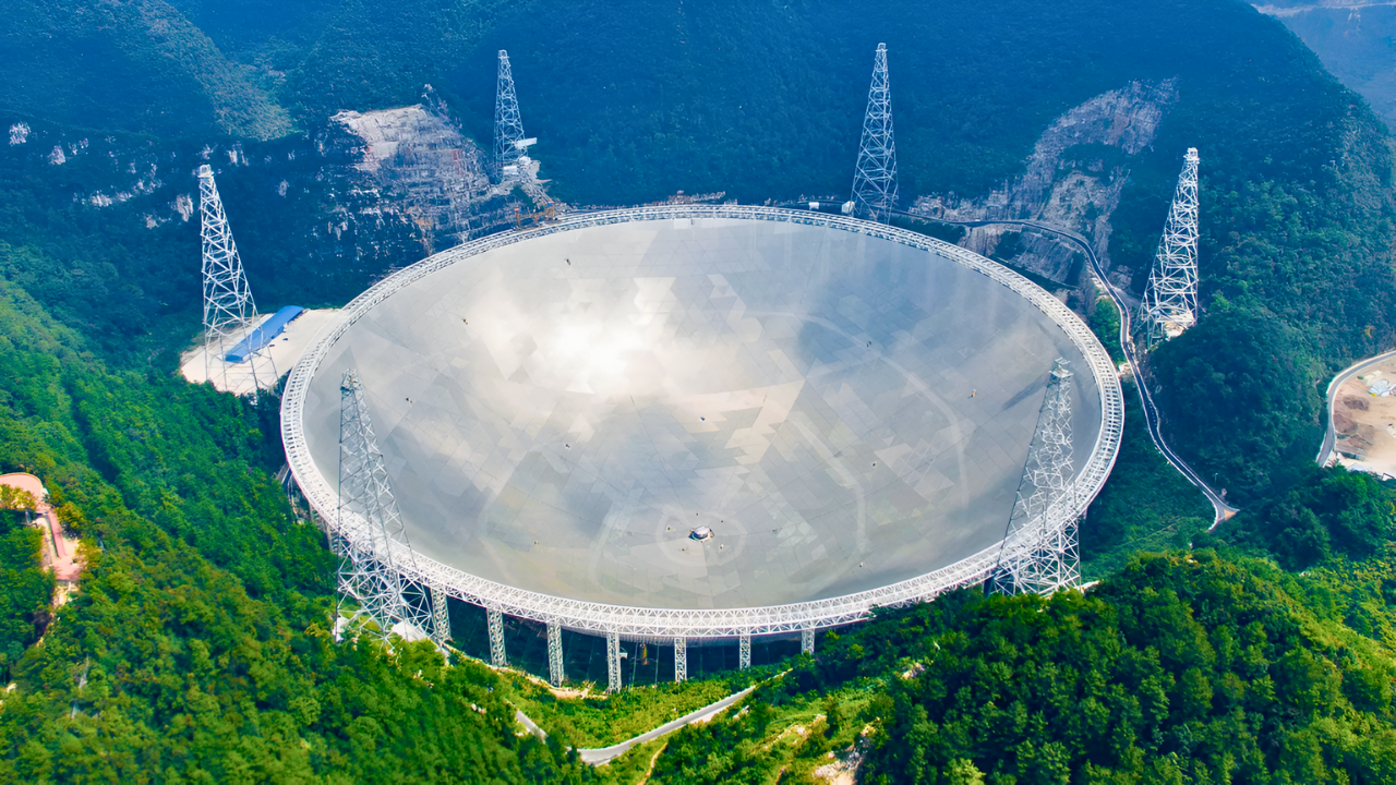
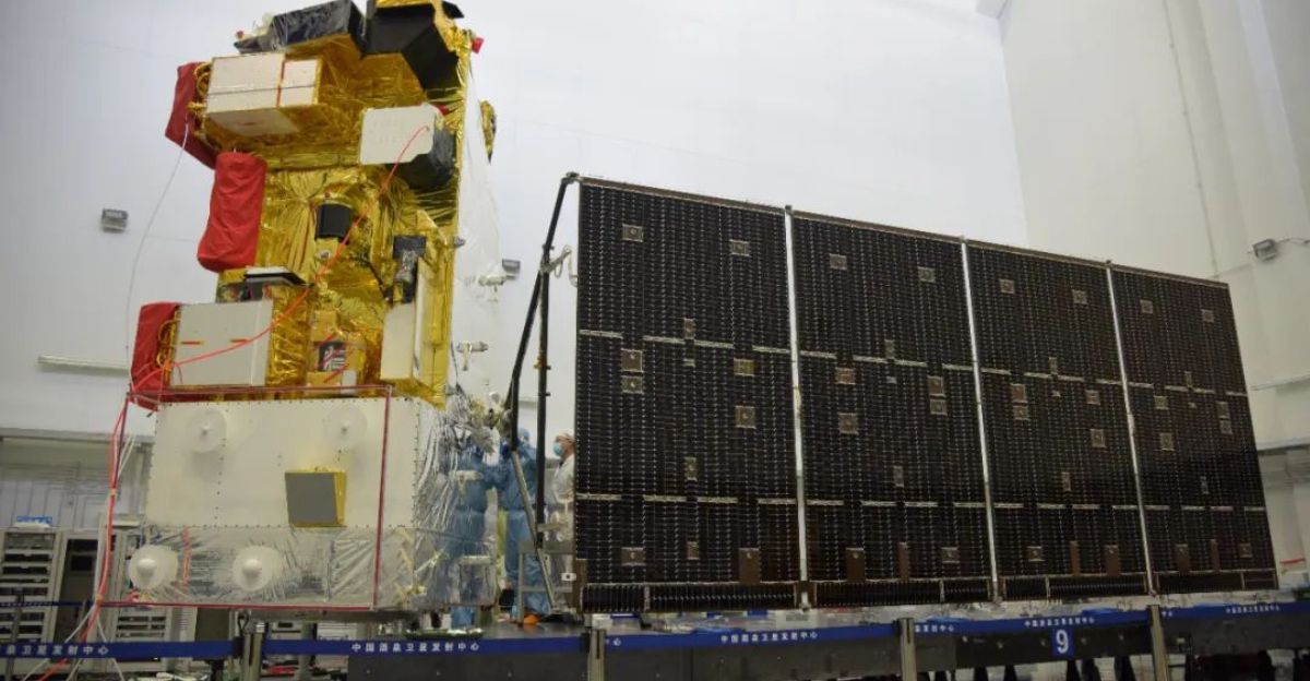
China has built what it claims is the most sophisticated weather monitoring system on Earth, combining ground, air, and space technologies to provide comprehensive coverage of the entire planet. The largest coordinated meteorological observation network in the world, this system consists of over 90,000 ground-based observation stations, 842 weather radars, and nine Fengyun meteorological satellites.
The China Meteorological Administration (CMA) reports improved early warning capabilities for storms and extreme weather, forecasting accuracy at the highest historical levels, and an 83% detection rate for severe weather. In addition to safeguarding China, this network hopes to support global climate cooperation and resilience by providing data services.
Evolution in History
During its 14th Five-Year Plan (2021–2025), China accelerated its meteorological modernization efforts by prioritizing significant investments in satellite technology and observation infrastructure.
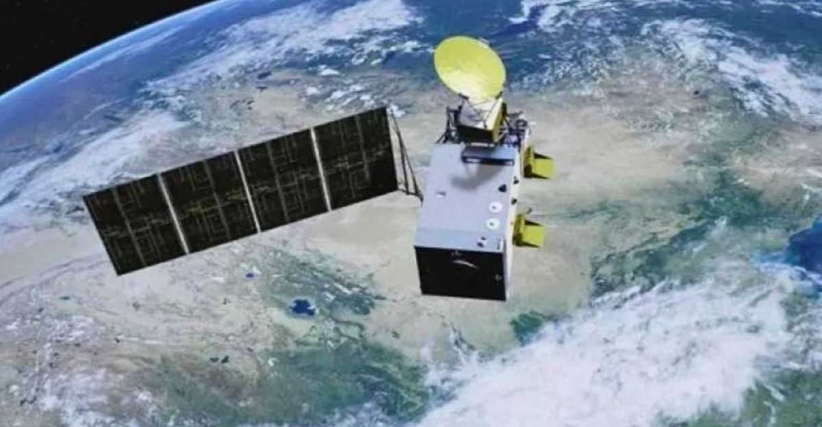
China has advanced from basic weather monitoring to the launch of a number of Fengyun satellites with noteworthy innovations: FY-4B has the first regional imaging with a resolution of 250 meters, and FY-3E monitors exclusively at dawn and dusk, filling in long-standing gaps in global observation. The radar network has grown significantly over the last five years and now covers more than 90% of areas with a high population density.
Innovations in Technology

The Fengyun satellites, modernized weather radars, and BeiDou navigation integration are essential components of this network. The GPS monopoly in meteorological air sounding has been broken by BeiDou, China’s independently developed satellite navigation system, which has improved radar coverage and accuracy.
The satellites provide unparalleled precision in global climate monitoring and continuous regional imaging. A multi-layered observational grid is created by ground systems, which comprise not only fixed observation stations but also commercial meteorological satellites and high-altitude sensors.
Reduction of Disaster Losses
The network has observable economic effects: according to CMA data, China’s disaster loss share of GDP decreased by 0.12 percentage points between 2021 and 2025.
Direct losses have been reduced, particularly in vulnerable urban and coastal areas, thanks to early warning systems and increased precision in identifying storms, heavy rains, and extreme events. Better forecasts, for example, have made it possible to evacuate people quickly and protect infrastructure, as evidenced by the fact that more powerful typhoons and floods have caused less economic and human damage.
Unrivaled Integration and Coverage

China’s system provides unmatched observational density and breadth, encompassing land, sea, air, and space. Nine satellites offer high-resolution, multispectrum worldwide monitoring; 842 radars improve volumetric precipitation and storm structure analysis; and more than 90,000 ground stations provide real-time surface data.
The creative use of 35 small commercial meteorological satellites to augment government resources is another aspect of this integration that promotes data resilience and diversity.
International Collaboration and Contributions

China helps dozens of nations in Asia, Africa, and Latin America prepare for disasters and manage climate risk by sharing Fengyun satellite data with them. China is now a leader in South-South cooperation on meteorological science thanks to CMA’s cooperation programs that support developing nations’ climate resilience through training and technology transfer.
This method promotes a global public good model in the context of mitigating and adapting to climate change, challenging conventional narratives that claim meteorological data is only a strategic asset.
Overcoming Obstacles
Overcoming significant logistical and technical obstacles, such as harsh geographic diversity, data harmonization across multiple platforms, and the development of AI-driven forecasting models, was necessary to build and synchronize this extensive observational network. GPS dependency vulnerabilities are fixed by China’s autonomous BeiDou system.
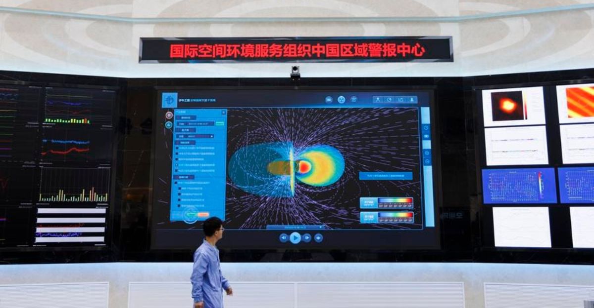
Furthermore, moving IT infrastructure to cloud-based, distributed architectures was necessary to manage massive data flows while guaranteeing high temporal and spatial resolution data. This also meant developing new radar and satellite technologies, especially for space weather, where communications and satellites are affected by ionospheric disturbances.
Forecasting Tropical Cyclones
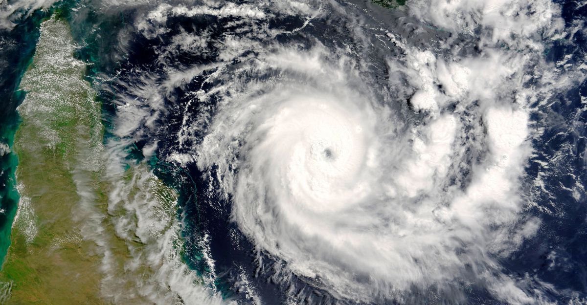
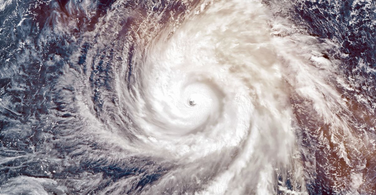
The effectiveness of the network is demonstrated by China’s progress in tropical cyclone (TC) forecasting, where track forecast errors have significantly decreased, particularly for longer lead times. Errors in sustained wind speed forecasts have decreased by roughly 0.26 m/s annually due to improvements in intensity prediction accuracy.
For tens of millions in typhoon-prone east Asia, this improves early warnings. Still, subtle trends persist, such as overestimating weaker cyclones and underestimating stronger ones, underscoring the need for further improvement. This instance highlights the critical connection between cutting-edge data collection and operational meteorology that can save lives.
Impact on Strategy and Psychology

In addition to reducing physical risk, improved forecasting increases community resilience and lessens the stress and trauma brought on by disasters. Reliable early warnings reduce anxiety and increase evacuation compliance by providing crucial preparation time.
By protecting vital infrastructure and urban areas from climate extremes that are intensifying as a result of global warming, China’s weather surveillance network strategically strengthens national security. Additionally, it strengthens China’s position as a global leader in science and technology, extending its influence through weather and climate services—a crucial soft power link in geopolitics.
Upcoming Collaborations
Unprecedented opportunities arise when space weather monitoring and terrestrial meteorology are combined. Forecasts of solar storms can now better safeguard ground power grids and satellites.
Furthermore, combining meteorological data with artificial intelligence, satellite imagery, and Big Data analytics creates opportunities for disaster logistics optimization, smart city development, and precise agriculture. As a result, China’s network can work in tandem with the fields of urban planning, environmental preservation, and the digital economy to turn weather data into a vital component of integrated national resilience and economic modernization plans.
Critical Evaluation

Skeptics might raise concerns about the geopolitical use of China’s meteorological network, data transparency, or potential militarization. Although China’s system is technologically sophisticated, some contend that forecast accuracy isn’t perfect and that even the best surveillance may not be able to keep up with the growing unpredictability of climate change.
However, worries are lessened by embracing openness through cooperative technology transfer and global data sharing. Crucially, China’s size and investment set a standard that challenged long-standing Western models, pushing rivals worldwide to innovate rather than rely on their success.
Extreme Cases Showing the Significance

Beijing’s record-breaking heavy rains, which killed 44 people and caused extensive damage, are a prime example of the difficulties advanced forecasting faces. More than 100,000 residents were evacuated in large numbers as a result of early alerts that prompted emergency responses. Despite being severe, this event was predicted with greater accuracy and lead times, allowing for mitigation as opposed to a surprise catastrophe.
These instances highlight the system’s societal value by validating the network’s crucial role in rapidly changing climate contexts where the frequency and intensity of extreme weather events grow abnormally quickly.
Distinct Frameworks

The “Meteorological Resilience Pyramid” is a helpful conceptual model. Heavy multi-source data collection is at the base, real-time analysis and AI forecasting are integrated at the mid-level, and impact-based warning, decision support, and socioeconomic response are delivered at the apex.
China’s network serves as a model for future weather systems worldwide, covering the entire pyramid at scale: the densest base, the most advanced middle, and the actionable apex. This framework highlights how crucial it is to combine information flow, technology, and human-centered impact assessment in order to mitigate disasters.
Unexpected Data Findings

Despite the magnitude, China’s network detects roughly 80% of catastrophic weather events, with a focus on small- and medium-sized phenomena that are frequently more difficult to record, such as tornadoes and hail. Few countries have the ability to forecast annual climate trends for up to a year with increasing reliability.
A further quantitative effect of meteorological modernization is the reported 0.12 percentage-point GDP reduction in disaster losses, which may seem small but adds up to tens of billions in avoided losses each year. Last but not least, a crucial but little-known factor in stability is the support provided by the network’s data assets for supply chain risk mitigation.
In Conclusion

A major national accomplishment and a major international contribution to meteorology and climate resilience is China’s integrated weather surveillance network.
It establishes a new benchmark for thorough planetary observation by combining satellites, radars, ground stations, and sophisticated data analytics. Through collaboration and data sharing, this infrastructure improves early warning, quantifies disaster losses, and spreads benefits across national boundaries.